Air Line Trail / Star Lake Trail / less than 50 feet from summit - turned back due to dangerous wind gusts / Star Lake Trail / Valley Way
Pulled into the Appalachia Trailhead parking lot and was surprised to see about 10 cars already there. Temperature at the trailhead was a "balmy" 35 degrees for my first "official" winter hike of the season. I started up Air Line and the trail had a light coating of new snow over a hardened crust of snow and ice, but I didn't need any traction until about an hour into the hike. I kept shedding layers and wondered if any of the boot prints along the way were from this morning, as they appeared to be a couple of days old. I followed what seemed like miles of rabbit tracks in the fresh coating of snow heading up the trail with numerous side paths of tracks into the woods. I was half tempted to do some bushwhacking and see where those rabbits were headed!
Until I hit Durand Ridge the trail was protected from the wind by the forest cover, but sections of trail would become very loud with the wind gusts moving through the trees and I kept looking up for any loose branches getting ready to drop on me. Once I hit the clearing at Durand Ridge, I got my first taste of what the wind would be like today. After getting blasted as I left the tree cover, I quickly retreated to throw on my shell and a second layer of gloves and then got my essential wind gear stuffed into my shell for later.
There were a few impressive "wind tunnels" along the ridge including an incredible sustained gust ripping across the junction of Air Line and Chemin des Dames. The wind was strong, but not "knock you over" strong, so I kept going. Not much visibility into King Ravine today, but I was able to spot the RMC Crag Camp across the ravine. As I continued climbing, trail visibility was about 30-40 feet ahead of me, and Madison Hut appeared out of the fog. I ran into the first people (and dogs) I saw, who started early and were regrouping near the hut before heading on their way back down. I didn't stick around to chat as I wanted to keep going so I don't know if they were able to bag a summit.
I decided to take Star Lake Trail up in order to hopefully avoid some of the wind. Star Lake was frozen solid and the wind picked up as I started heading up the steep southeast side of Mount John Quincy Adams. About half way up, the wind was in full force and I threw on the balaclava and goggles. There was some fun scrambling using all fours up some tricky sections near the crest. Once I hit the ridge crest and took about 5 steps, I felt the full force of the very powerful, sustained wind whipping over the ridge. Every step was a tremendous effort to maintain balance. Once I lifted a leg to move the wind would push me around (now I know what a rag doll feels like). It was really amazing to feel the powerful force of Mother Nature. I only made about 10 steps and hunkered down for a couple of minutes hoping this was a gust that would die down, but it was not to be. I took a quick video before the camera shut down on me and wondered how close I actually came to the summit (I knew I was very close, but there was no way I was going any further I that wind). I started thinking about any loose items attached to my pack which might go flying off the ridge and thankfully I had all my gear stowed securely in the pack. Later my GPS track would reveal I was less than 50 feet from the summit (give or take the usual margin of error on those things). I will return!
I made my way back down Star Lake Trail and ran into two guys heading up who had to bail on Madison due to high winds and were hoping to summit Adams. I told them what it was like for me and wished them luck as I continued back down. After a quick break near the hut, I headed down Valley Way, which was much more broken in compared to Air Line. I passed a couple of more groups heading down, who also had to bail on summiting either Madison and/or Adams.
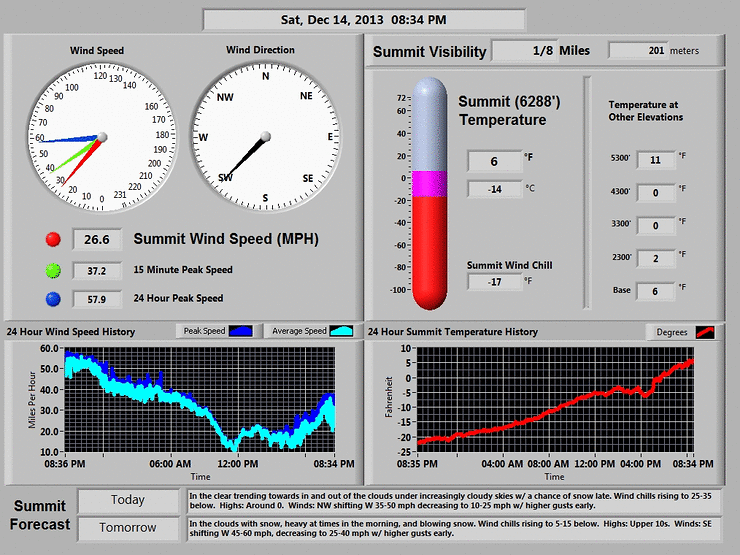
Any day in the mountains is a good day. A review of the Mount Washington Observatory website indicated winds from 70-90 mph at the summit. The videos I took of that wind really doesn't capture how powerful and unrelenting those gusts were.
As a side note, I was able to test out some new gear with great results. I brought out a new Patagonia R1 full zip jacket which was my outer layer below tree line and probably would have remained my outer layer on a calmer day. It's really warm and compresses down to next to nothing in my pack. I also splurged for a pair of Oakley A Frame goggles, since most reviews I read were very favorable on no fogging. These goggles are worth every penny, as I did not fog up at all, which usually happens for me once the balaclava goes on.
Appalachia Trailhead
Air Line Trail begins
Air Line Trail
Air Line Trail
Air Line Trail
Air Line Trail
Air Line Trail
Air Line Trail - Ice Begins
Air Line Trail - Ice Begins
Air Line Trail - Rabbit Freeway!
Air Line Trail - Rabbit Freeway!
Air Line Trail
Air Line Trail
Air Line Trail - RMC Crag Camp
Air Line Trail
Air Line Trail
Air Line Trail
Madison Hut
Madison Hut
Madison Hut
Madison Hut
Star Lake Trail
Star Lake Trail
Star Lake Ice Rink
Star Lake Ice Rink
Star Lake Trail
Back down from summit - crunchy shell
Looking down from Madison Hut
Valley Way Sign down
Valley Way Ice
Summit Conditions - Wind, Wind, Wind
Google Earth Image of Hike
Valley Way - Ice frozen on trees at lower elevations
12/28/2013 Air Line Trail - Windy Forest
12/28/2013 Air Line Trail - 2900 feet elevation - very windy
12/28/2013 Air Line Trail junction with Chemin Des Dames Trail - SUPER Windy
12/28/2013 Near Mount Adams Summit (less than 50 feet)- incredible wind gusts
Saturday 12/14/2013 Mount Washington Ammonoosuc Ravine Trail / Lake of the Clouds Hut / Crawford Path / Mount Washington / Trinity Heights Connector / Gulfside Trail / Jewell Trail Since we got turned around heading to Mount Washington yesterday, I wanted to give it another crack today. While a major snowstorm was hitting late afternoon, the forecast for the beginning of the day looked pretty good. I wanted to check out all of the falls on the Ammonoosuc Ravine Trail and I was hoping to see some cool ice along the way. I headed up Base Road and saw some plow trucks working the Cog Railroad Parking area, so I parked below and took the normal trail head into the woods. Temperature at the start was a mild 5 degrees with no wind.
No need for any traction and the lower water crossings were almost completely iced over with partial snow bridges. The trail was mostly covered with an inch or two of fresh snow and there were plenty of small game tracks all over the trail, but no boot prints. Every now and then the trail would open up a bit and some nice initial views of the ravine would come into sight.
After about 2 hours of hiking, I hit 4,000 feet and the trail rose steeply with some serious sections of ice ahead. I stopped and threw on the crampons and started to climb up the ice. Soon some amazing views would appear every time I looked back. Before long I was at the spot where the trail levels off a bit and turns right to cross the brook. Looking up, spectacular views of the frozen falls are ahead. There is still water running but there is enough ice and snow to make the crossing easy.
I keep heading up this fun part of trail that goes back and forth between tree lined snow covered trail and large flat clearings with lots of ice and views of Mount Washington's towers to the left. As I keep heading up I notice a rainbow has appeared ahead of me. Just an amazing sight!
The ice keeps coming and I take my time navigating up the steep sections, but it's very manageable and lots of fun. I know I'm getting close to the Lake of the Clouds Hut and I get my first good view of Mount Monroe to the right. The Hut pops into view and before long I am taking a break on the bench. I start heading on Crawford Path and get some nice shots looking back at Mount Monroe and the Hut with the frozen lake.
There is a steep, angled section of Crawford Path which is a very thin layer of wind blown crusty snow, which takes some care, only because a slip would send you sliding down for a good 20-30 feet. Soon the angle levels off and more gradual climbing continues. Some awesome views of the Southern Presidentials emerge and the Ravine I came up is easily viewed.
I make the final push to the summit and the wind picks up a bit. Just as I reach the summit, two guys approach from the Tuckerman Ravine Trail (the only people I would see all day). We wait for two more of their group to show up for their summit photos. They took Lion Head up and want to take Boott Spur Trail down, but they don't have a map. I explain they will have to take a few trails to get there and take off the outer layers of my gloves and pull out my map to show them the best way to get there. They were under the impression that Boott Spur started at the summit (how does this happen????). After about a minute, I send them on their way, slap my outer gloves back on and head down the Trinity Connector.
I am treated to awesome views of Clay, Jefferson, Adams and Madison, the pictures really don't do it justice. At this point, my left hand has not really warmed up from the summit, and I know I left it exposed too long at the summit (even though the liner was one he entire time), so I stop to pull out some warm, toasty gloves which had been stashed under my shell next to my body. Wow, almost instantly my hand comes back to life and I'm back in business as I hook up with the Gulfside Trail.
There is one tricky section of the trail before the junction with Westside Trail that was the only part of the hike that caused me some concern as the icy section was angled off with a drop right into a ravine on the right. I skirted off to the left and steered clear of the whole area that was too close to the drop off for my taste. After the junction with Westside, the trail became crampon unfriendly as the mixture of rocks with sporadic ice and snow really slowed me down for the final half mile or so to the junction with Jewell.
Views of the Cog Railroad heading all the way down along with views of the train station and parking lot down below came into view. I hit the junction with Jewell and took off the crampons for the trek down. With about 2 hours or so of daylight left I started down Jewell. Not too far down, I managed to lose the trail (which veered left, while I went straight). I probably got about 50-100 feet down before I realized I was slightly off course. When the trail is snow covered above tree line it doesn't take long to potentially lose the trail. I stopped, pulled out the GPS, did some quick recon and decided I could head back up to the last cairn I saw or start cutting across to the left. I compromised and climbed back up about 20 feet then started to scoot across the left and slightly down. I eventually picked up the trail again and was lined up to enter the tree line. Unfortunately, the "detour" ended up costing me some precious daylight which would mean some headlamp time down below.
There were a couple of blowdowns along the way, but with darkness falling I reached a point about a mile from the trail head where the path was not easy to figure out. I kept going straight for a while, but figured I must have missed a turn. I headed back to a small clearing and navigated through a very dense blowdown of three trees which totally blocked a view of a footbridge crossing the water. After that, it was time for the headlamp for the final push to the car.
By the time I made it back to the car, it was really getting cold with a light snow shower falling. On the way back south, the snow really started to pick up around Exit 23 on 93 and it was slow and steady driving. Just an awesome day!
.JPG)
.JPG)
.JPG)
.JPG)
.JPG)
.JPG)
.JPG)
.JPG)
.JPG)
.JPG)
.JPG)
.JPG)
.JPG)
.JPG)
.JPG)
.JPG)
.JPG)
.JPG)
.JPG)
.JPG)
.JPG)
.JPG)
.JPG)
.JPG)
.JPG)
.JPG)
.JPG)
.JPG)
.JPG)
.JPG)


.JPG)
.JPG)
.JPG)
.JPG)
.JPG)
.JPG)
.JPG)
.JPG)
.JPG)
.JPG)
.JPG)
.JPG)
.JPG)
.JPG)
.JPG)
.JPG)
.JPG)
.JPG)
.JPG)
.JPG)
.JPG)
.JPG)
.JPG)
.JPG)
.JPG)
.JPG)
.JPG)
.JPG)
.JPG)
.JPG)
.JPG)
.JPG)
.JPG)
.JPG)
.JPG)
.JPG)
.JPG)
.JPG)
.JPG)
.JPG)
.JPG)
.JPG)
.JPG)
.JPG)
.JPG)
.JPG)
.JPG)
.JPG)
.JPG)
.JPG)
.JPG)
.JPG)
.JPG)
.JPG)
.JPG)
.JPG)
.JPG)
.JPG)
.JPG)
.JPG)
.JPG)
.JPG)
.JPG)
.JPG)
.JPG)
.JPG)
.JPG)
.JPG)
.JPG)
.JPG)
.JPG)
.JPG)
.JPG)
.JPG)
.JPG)
.JPG)
.JPG)
.JPG)
.JPG)
.JPG)
.JPG)
.JPG)
.JPG)
.JPG)
.JPG)
.JPG)
.JPG)
.JPG)
.JPG)
.JPG)
.JPG)
.JPG)
.JPG)
.JPG)
.JPG)
.JPG)
.JPG)
.JPG)
.JPG)
.JPG)
.JPG)
.JPG)
.JPG)
.JPG)
.JPG)
.JPG)
.JPG)
.JPG)
.JPG)
.JPG)
.JPG)
.JPG)
.JPG)
.JPG)
.JPG)
.JPG)
.JPG)
.JPG)
.JPG)
.JPG)