Mount Washington Tuckerman Ravine Trail / Boott Spur Trail / Davis Path / Lawn Cutoff / Tuckerman Ravine Trail / Mount Washington / Tuckerman Ravine Trail / Lion Head Trail / Tuckerman Ravine Trail
Saturday, November 30, 2013
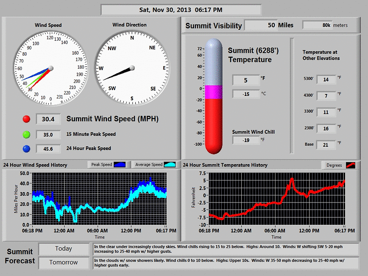
The weather forecast for Mount Washington called for "in the clear with increasingly cloudy skies" with a high of 10 degrees with wind chills around -15 to -25 degrees at the summit. I set off for Pinkham Notch with temperatures around 20 degrees and I watched it steadily go down during the ride up north. After a quick stop in Lincoln at White Mountain Bagel, I was at the 3/4 full parking lot around 7:45, where the temperature was a brisk 5 degrees. There was not a cloud to be seen with blue skies in every direction. After gearing up, I was on my way and quickly had to stop to throw on my micro spikes at the start of the trail. As usual, there was a steady flux of folks heading up the first segment of the Tuckerman Ravine Trail. The sun was shining and it was shaping up to be a perfect day with high visibility.
I decided early on to get away from the crowds and take the Boott Spur Trail up. It's a little longer and is exposed to more wind, but the views are much better from a couple of outlooks and then above treeline. After making the first significant ascent early on in the trail, I needed to take off a couple of layers as it was surprisingly warm and I didn't want to start sweating. It's hard to imagine how hot it can get climbing up the mountain when it's only 5 degrees, but you would be surprised. As I reached the first small clearing, I let three other guys pass me (2 together and 1 solo) and they would be the only people I would see on this section. The solo guy was doing an abbreviated day hike up to Split Rock and maybe a little further before heading back down. He kindly took a photo of me with Washington in the background and he set off ahead of me. This section of trail headed up to the outlooks was very icy, but overall pretty easy to navigate with no real tricky spots. At the last outlook before going above treeline, fantastic views of the ravine and surrounding summits could be had, with no clouds threatening to fog in the summit. By this point, the wind and elevation made things a little colder and I threw back on my two layers and headed for the treeline.
Once you break through into the clearing, there was nothing but crystal clear skies. The trail became less snow covered and more icy and the wind picked up a bit. Before long I was at Split Rock and continued up the ice. After taking my time along the way to turn around and enjoy the views, I reached the junction with the Boott Spur Link and further up the trail the junction with Davis Path. By this time the wind was really picking up and I stopped behind a large boulder to put on my balaclava and have have my Neoprene mask handy. Of course my sunglasses started to fog, so I removed them knowing I had goggles if conditions deteriorated (they did not!) As I was on Davis Path headed towards the Lawn Cutoff, I heard and then eventually saw a large green helicopter with a red cross on it flying around the summit of Washington. I hoped to myself they were just training and there was no rescue needed. This helicopter would come and go the rest of the day. As I continued on the Lawn Cutoff, I started to spot groups of people making their way up to the summit on Tuckerman Ravine Trail. I eventually hit the junction with Tuckerman Ravine Trail and started the final 1/2 mile or so push to the top. A few folks were headed down and I passed a large group that may have been staying at the observatory as they all had sleeping mats.
I reached the summit almost the same time as another guy behind me and we took the obligatory photos of each other. We both commented on how lucky we were to get such an amazing day of weather on the summit. The pictures and video really don't capture how fantastic it was up there. I walked around the deserted summit area and my camera held up to the cold so I could take some more shots (the hardest part was keeping my hands relatively warm). Finally it was time to head back down, although I was in no rush to go. I stood behind one of the buildings to get some shelter from the wind to grab a drink, then started down Tuckerman Ravine Trail, where the large group was almost hitting the road.
I turned left on Lion Head to take in the ravine and I spotted a couple of folks in there heading down. Some sections of Lion Head were extra snowy, but most of the flatter sections of the trail above tree line were very icy. During my trek here, the same helicopter made a low pass right over me, circled over the ravine then made one more pass before leaving. I passed two groups of people heading up and wished them luck. As I descended the summer route, sections of the trail became very steep and icy. The sun was going down and temperatures were dropping even though I was losing elevation. Before long I was back at the junction with Tuckerman Ravine Trail for the final mile or so out to the trailhead.
Mount Washington is always one of my favorite hikes, as I have done it with lots of different people and it has many great memories. The weather today really stands out. Even with great weather, that summit is fogged in more often than not. Today, the entire hike up and down offered spectacular views in every direction!
.JPG)
.JPG)
.JPG)
.JPG)
.JPG)
.JPG)
.JPG)
.JPG)
.JPG)
.JPG)
.JPG)
.JPG)
.JPG)
.JPG)
.JPG)
.JPG)
.JPG)
.JPG)
.JPG)
.JPG)
.JPG)
.JPG)
.JPG)
.JPG)
.JPG)
.JPG)
.JPG)
.JPG)
.JPG)
.JPG)
.JPG)
.JPG)
.JPG)
.JPG)
.JPG)
.JPG)
.JPG)
.JPG)
.JPG)
.JPG)
.JPG)
.JPG)
.JPG)
.JPG)
.JPG)
.JPG)
.JPG)
.JPG)
.JPG)
.JPG)
.JPG)
.JPG)
.JPG)
.JPG)
.JPG)
.JPG)
.JPG)
.JPG)
.JPG)
.JPG)
.JPG)
.JPG)
.JPG)
.JPG)
.JPG)
.JPG)
.JPG)
.JPG)
.JPG)
.JPG)
.JPG)
.JPG)
.JPG)
.JPG)
.JPG)
.JPG)
.JPG)
.JPG)
.JPG)
.JPG)
.JPG)
.JPG)
.JPG)
.JPG)
.JPG)
.JPG)
.JPG)
.JPG)
.JPG)
.JPG)
.JPG)
.JPG)
.JPG)